Free soil research
How to Use USDA Web Soil Survey for a Dallas–Fort Worth Property
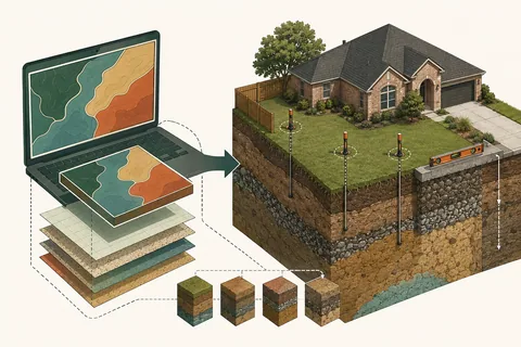
USDA Web Soil Survey provides mapped soil units and interpretations that can improve early drainage questions, but it does not replace field verification, elevations or a property-specific design.
Open Web Soil Survey, define an Area of Interest around the property, review the Soil Map, then use Soil Data Explorer for drainage-related properties. Treat the result as regional planning evidence: grading, imported fill, construction and utility work may have changed the actual yard.
Reviewed September 3, 2026 · Dallas–Fort Worth homeowner guide
Start with the right expectation
A soil map is a planning tool, not a backyard diagnosis
The USDA Natural Resources Conservation Service publishes Web Soil Survey as the authoritative online source for current soil survey information. It identifies mapped soil units, typical profiles and interpretations across a selected area.
For drainage, the map helps ask better questions: Is the unit commonly fine textured? Is slow permeability expected? Are restrictive layers or flooding frequency noted? It does not show the exact position of every soil boundary at residential scale.
Web Soil Survey workflow
Define the property, open the map and build a focused report
- Open Web Soil Survey and choose “Start WSS.”
- Find the location by address or map navigation.
- Set the Area of Interest around the property and nearby drainage context.
- Open Soil Map and record each unit name, symbol and percentage.
- Use Soil Data Explorer for water, construction and landscape interpretations.
- Save a dated report containing only the relevant sections.
Include uphill and downhill context when practical; a parcel boundary alone may hide the source or outlet.
Drainage questions
Which soil properties are most useful
| Property | Why it matters |
|---|---|
| Texture by depth | Typical sand, silt and clay proportions through the profile |
| Drainage class | General frequency and duration of wet conditions |
| Hydrologic soil group | Supports runoff estimates, but is not an installation specification |
| Restrictive layer depth | May affect storage, trench depth and infiltration feasibility |
| Flooding or ponding | Flags landscape-scale conditions needing investigation |
Compare the mapped profile with a simple soil ribbon test at several representative points.
Scale matters
What Web Soil Survey cannot prove
Web Soil Survey does not locate property lines, utilities, drainage easements or a safe discharge. It does not replace a topographic survey, infiltration test, geotechnical evaluation or engineering analysis. Development may contain imported fill, compacted subgrade, buried debris and amended topsoil.
Do not size an infiltration system from the mapped hydrologic group alone. Actual rate, storage and recovery require site-specific evaluation, especially near foundations and on commercial sites.
Verify in the yard
Connect mapped information to observable evidence
Record surface slope, exposed texture, dry cracking, compaction, fill transitions, test-hole behavior and recovery time. Compare several points rather than one planting bed. Review how soil affects drainage for the practical implications.
Before any test hole or excavation, contact Texas 811. Public utility marking does not necessarily identify irrigation, private electrical, pool lines or other privately owned facilities.
Use the map to improve the assessment checklist and explain uncertainty—not to promise a system from a screen.
Sources and further reading
- USDA NRCS — Getting Started with Web Soil Survey
- USDA NRCS — Web Soil Survey Data and Reports
- USDA — Web Soil Survey Application
- Texas 811 — Frequently Asked Questions
External sources support homeowner education and do not imply endorsement of Texas Yard Drainage. This guide is general information, not an engineering report or a property-specific design.
Continue the topic
Related drainage guides and problem pages
Homeowner FAQ
Questions this guide should answer
These answers help with early diagnosis. Actual recommendations still depend on the property.
Is USDA Web Soil Survey free?
Yes. It is a free browser-based service provided by USDA NRCS.
Can I search by street address?
The interface supports location search and map navigation. Verify that the Area of Interest matches the intended property.
Does it show exactly what is in my backyard?
No. It represents mapped units at survey scale; construction and landscaping can change near-surface conditions.
Which data matter for drainage?
Texture by depth, drainage class, hydrologic soil group, restrictive layers and flooding or ponding notes are useful starting points.
Can it replace a site assessment?
No. Elevations, sources, utilities, field soil behavior and the outlet must be checked on site.
Need a property-specific answer?
Use soil data to ask better drainage questions.
A property assessment connects mapped context with actual flow, elevations and an achievable outlet.
See the Assessment Process